

This collection of photos from the USDA Soil Conservation Service includes 1,151 images made by local conservation agents covering activities from the late 1940's through early 1970's. Most are high quality 4" x 5" prints, often with negatives and mostly with documentation of location, date and other information. Content includes a wide range of farming-related activities, soil erosion and land uses in the Matanuska Valley. Also included are photos of a number of soils and snow surveys conducted in other parts of Alaska.


Anchorage Air View 1
USDA Soil Conservation Service
Anchorage, Alaska
Image shows an oblique view of Anchorage looking west from above the Pine Street intersection with the Glenn Highway.
Anchorage, Alaska
Anchorage Air View 2
USDA Soil Conservation Service
Anchorage, Alaska
Image shows an oblique view of Anchorage looking west from above 3rd Avenue at about the intersection with Reeve Boulevard.
Anchorage, Alaska
Colony Barns 6
Cliff Marcus
A typical Colony barn, chicken house and additional log structure make up part of a Matanuska Colony farmstead near Bodenburg Butte.
This summer photo shows a colony barn on a slight rise in near middle ground, with the oblique view exhibiting the front west-facing end and north wall. The small hay mow door stands open and several of the vertical boards of the upper mid-section are missing, presenting a somewhat "missing tooth" image. Otherwise, the structure appears to be in good condition. Several black and white cows are eating hay on the ground in front of the barn. A typical colony log chicken house stands next to the right side of the barn. A small log house-shaped structure with a peaked roof stands to the left behind the larger barn presenting a west-facing wall with two windows and a wide doorway with open door. The gable end faces to the left. The west side of Bodenburg Butte stands in near background at left. A flat gravel surface covers the immediate foreground quarter of the image with several wooden posts of a wire fence just beyond. A power pole stands at the far right of the image holding power lines crossing both ways across the upper image and also down to the barn as well as a yard light fixture.
Bodenburg Butte, Alaska
Colony Barns 7
Ted Freeman
The top portion of a Colony style barn exhibits some unique features as it presumably waits to be moved to another location and restored or repurposed.
This summer image shows the upper portion of a Colony barn with the lower log portion removed, sitting on a slight rise in a grass field in middle ground, presenting the front end to the right and north side to the left. It exhibits some atypical cross bracing boards on the front not seen on other barns, giving it a somewhat "cat-face" appearance. It also exhibits a larger and more ornate cupola on the roof than seen on other local barns. A group of broadleaf trees define the edge of the field at right and left behind the barn. Rounded form mountains are partially visible in background. A variety of white cloud forms dominate the bright sky overhead.
Matanuska Valley, Alaska
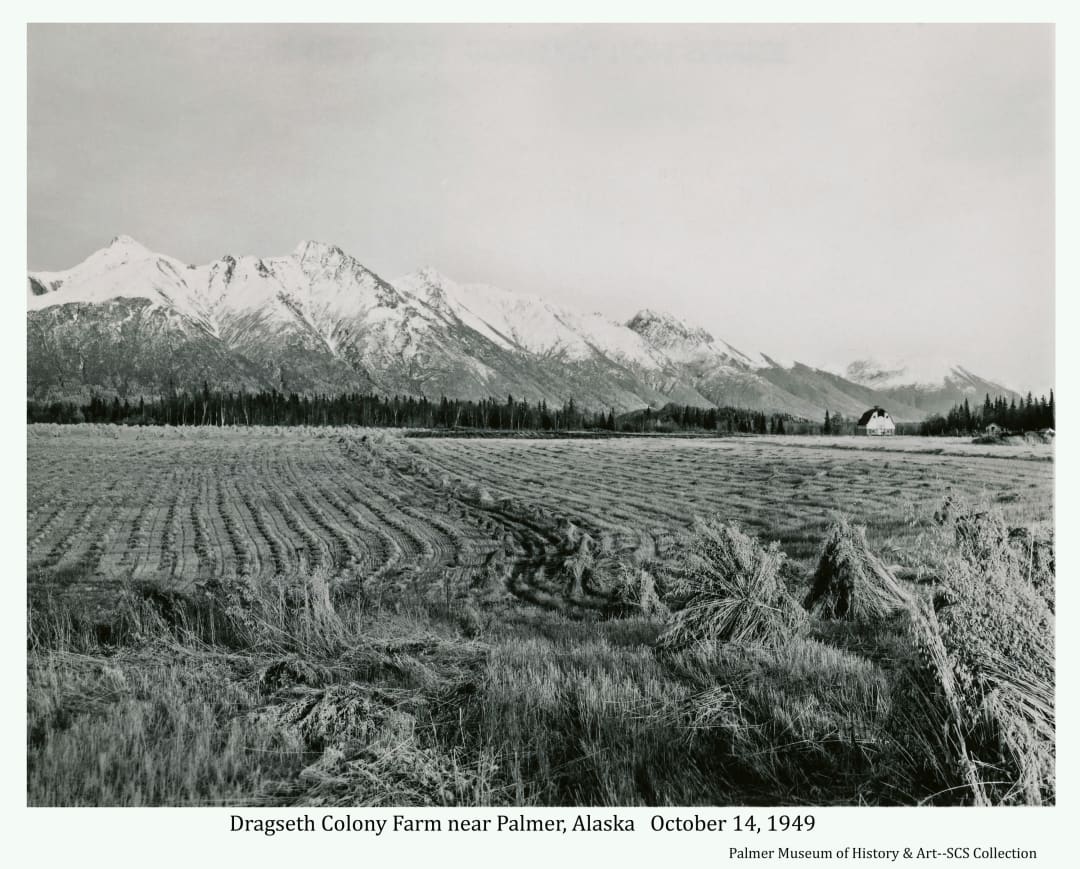
Colony Farm 47
T.H.Day
Grain harvest is well under way in 1949 on the Dragseth Colony farm near Palmer, Alaska.
This fall photo shows a recently harvested grain field on the Matanuska Colony farm of Joe and Velma Dragseth on tract 84 southeast of Palmer. Several shocks of harvested grain are seen in immediate foreground. Bundles of grain lie in rows over the whole field which takes up the major portion of the view in foreground and middle ground. Bundles have begun to be formed into shocks in a line through the center of the field from front to back. In far middle ground a narrow line of dark spruce forest extends across the image. At far right of this band of trees a typical Colony barn is apparent, and a couple of smaller structures are visible. Snow-covered Chugach Mountains are obvious in background.
Near Palmer, Alaska
Colony Farm 5
Tom Day, USDA Soil Conservation Service
Farm
Image shows a wire fence in foreground, numerous high tree stumps with several cows intermingled in the middle ground. Two typical Colony barns and other buildings are beyond with Bodenburg Butte and other mountains and forest in background. Caption: "Cows in stump pasture. One of the steps in land clearing."
Two Miles South of Palmer, Alaska
Erosion Control 1
Cliff Marcus, USDA Soil Conservation Service
Erosion Control Measures
Image is a low oblique view of several junk cars laid out in a curved line on a river gravel bar with logs between them. Extensive gravel expanse and the river channel are evident with mountains in background. Caption: "Butte area, shows cars as laid out for streambank control."
Near Bodenburg Butte, Alaska
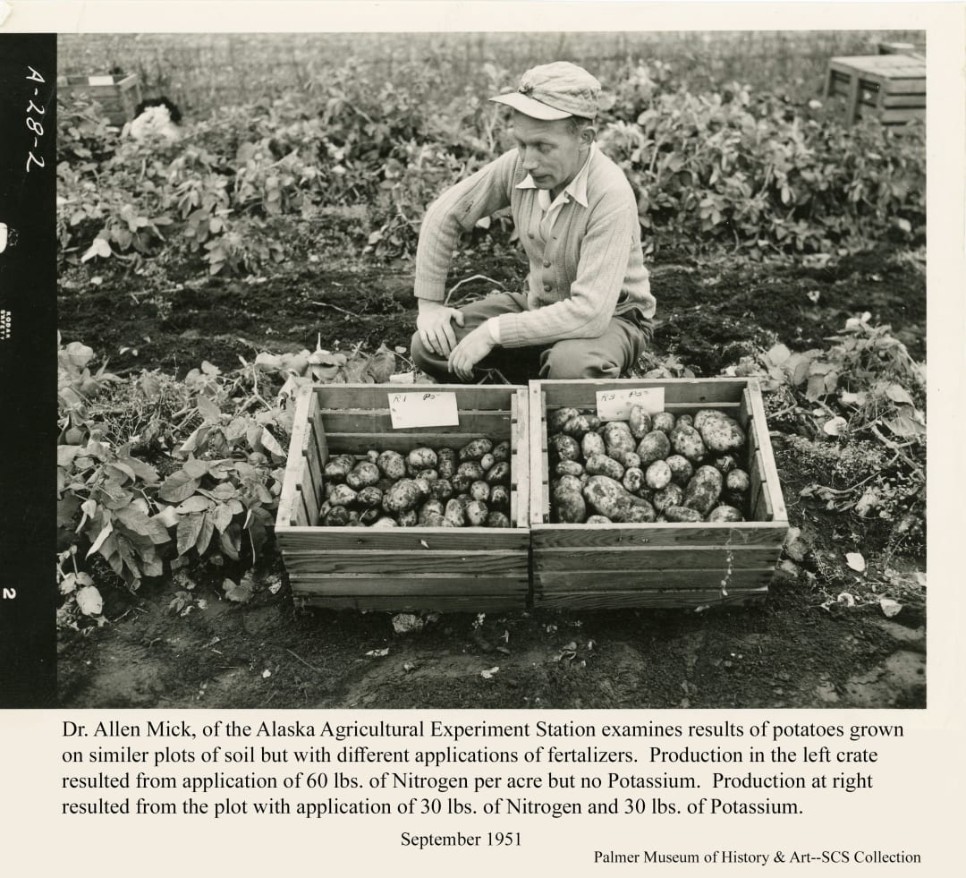
Experiment Farm 44
T.H. Day
Results from one of many experiments conducted at the Experiment Farm yield valuable information regarding proper fertalization of potatoes in certain soils.
Dr. Mick of the Agricultural Experiment Station examines two crates of harvested potatoes at the Experiment Farm which dramatically demonstrate the importance of proper fertilizer application. The crate at right showing production from the plot with added Potassium contains considerably more, and somewhat larger potatoes than the crate at left holding production from the plot receiving no additional Potassium.
Matanuska, Alaska
Farm 15
Cliff Marcus
Havemeister Colony farm on tract # 167
Image is of the farmstead of Colonists Arnold and Emmy Havemeister on tract # 167 along East Bogard Road between Palmer and Wasilla. A typical Colony barn and other outbuildings are evident. Dairy cows are visible in the pasture and feed lot. Snow-capped Chugach Mountains are in background.
Matanuska Valley, Alaska
Farm 28
Cliff Marcus
The Hamilton dairy farm south of Palmer is viewed on a pleasent summer day.
This photo shows the Hamilton dairy farm south of Palmer. The lower part of the photo shows a hay field across the image. The height of the grass, compared with a small patch of taller grass at left, appears to be in production of the second cutting to be harvested in the fall. In middle ground, at the far end of the field, are the farmstead buildings including the farmhouse at left and various barns, sheds, a silo and equipment in a line across the image to the right. Numerous black & white cows are standing in a feed lot in front of the barns. Directly behind the buildings a row of dark, thick forest crosses the image. A small background view of a portion of Talkeetna Mountains is seen at extreme left. A band of low white clouds lies across the image in background.
Palmer, Alaska
Farm 29
Cliff Marcus
A crop of oats and peas is being harvested on a Matanuska Valley farm to be turned into silage to feed local dairy cows.
This late summer view looks across fields of hay and grain on the Leonard Moffitt farm to the white structures of the Estelle farmstead in far middle ground. Chugach Mountains at the east end of the valley claim the background. A thick patch of birch and cottonwood trees intrudes into the field at left foreground and a large area of mixed spruce and deciduous forest in middle ground defines the far side of the fields at right. In immediate foreground and in a wide strip leading away from the camera are windrows of cut grain, identified as a mix of oats and peas intending to be converted into silage.
Near Palmer, Alaska
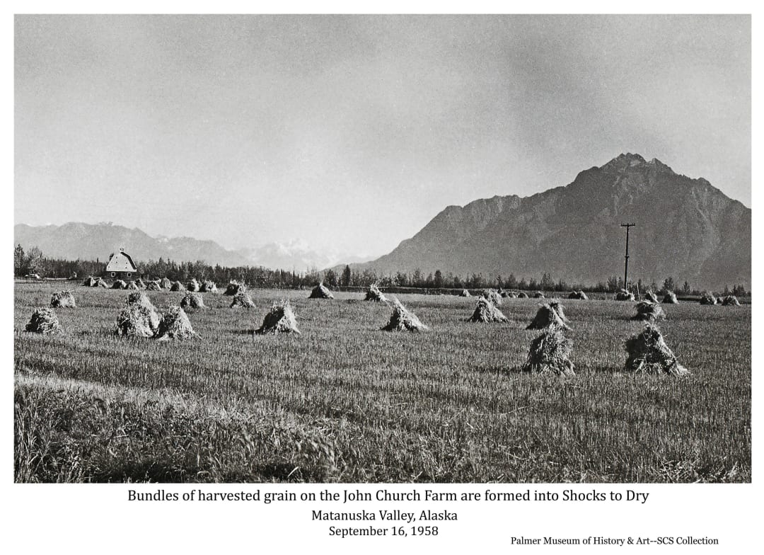
Farm 30
Cliff Marcus
The grain in this field has been harvested, probably cut with a "grain binder" machine which gathers the grain as it is cut into small bundles, ties the bundles with string ("binder twine"), and drops the bundles on the ground. A person then gathers three to five of these bundles and leans them together to form "shocks" shown here with the grain heads standing up to dry. These shocks are normally collected before winter sets in and taken to a threshing machine to remove the grain heads from the straw or to be stored for winter animal feed.
This fall image shows a harvested grain field in foreground and middle ground with numerous shocks of the harvested grain standing in the field. A "Colony Barn", painted white above the log bottom portion, is visible at far left in middle ground. A line of dark trees is apparent behind the barn and runs across the entire image in middle ground. A power pole is apparent in middle ground at right. Pioneer Peak is darkly obvious in near background across the right half of the image. Additional mountains are visible in far background at left.
Matanuska Valley, Alaska
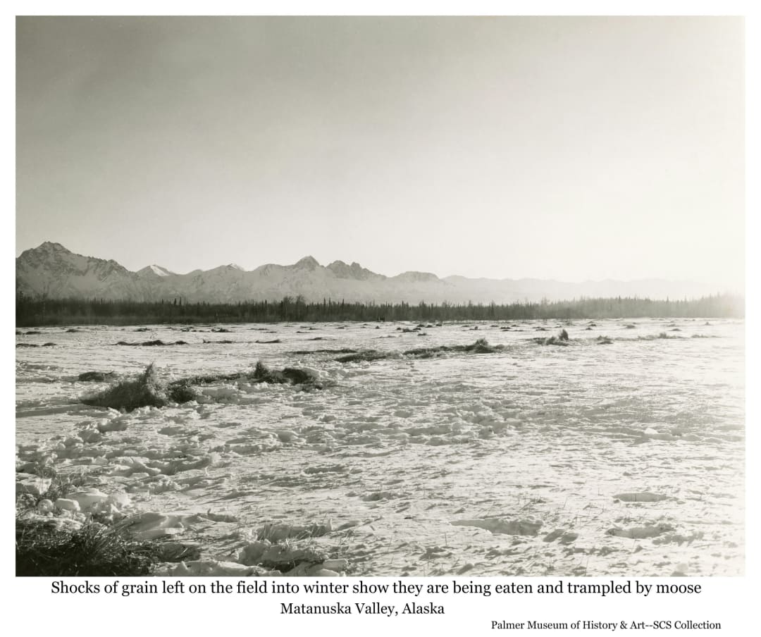
Farm 31
Emmett Ellington
Tracks in the snow and extensive destruction of the shocks of harvested grain left on the field give strong evidence that wintering moose will gain the sole benefit from this year's crop.
This winter image looks across a snow-covered field in foreground and middle ground exhibiting numerous remains of shocks of grain that were not removed from the field after harvest. Considerable tracks appear in the foreground snow and destruction of grain shocks appears to be extensive across the field. A strip of dark forest forms a line across the image in middle ground with snow-covered mountains in background.
Matanuska Valley, Alaska
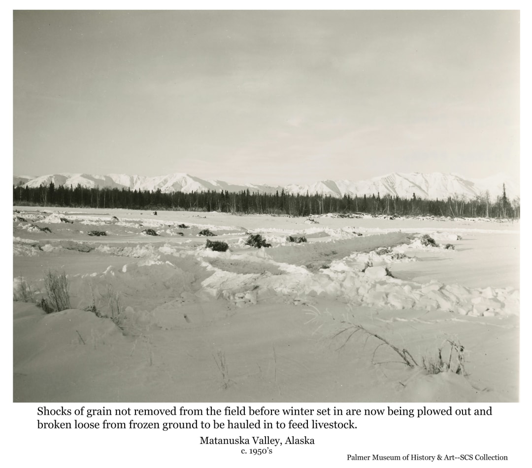
Farm 32
Lew Hanks
Shocks of grain left in the field to be frozen in and snowed under are now being plowed out and broken loose with a cat tractor. Accompanying note by the SCS Conservationist offer analysis: "Frozen hay shocks broken loose with bulldozer so they may be hauled to barn for feeding. Hay left out like this makes very poor forage. Illustrates an extremely sloppy farming practice common in the Matanuska Valley."
This winter image looks north across a field covered by approximately a foot of snow and extending from immediate foreground to an unbroken line of dark heavy forest extending across the photo in far middle ground. Snow-covered Talkeetna mountains are visible above the trees in background. Several shocks of grain are evident protruding above the snow in near middle ground. Several lanes have been plowed clear near the visible grain to provide access to the shocks to be broken loose from the frozen ground by the cat tractor. Snow berms along plowed sections appear approximately three feet high. An accompanying note by the SCS Conservationist offers some analysis: "Frozen hay shocks broken loose with bulldozer so they can be hauled to barn for feeding. Hay left out like this makes very poor forage. Illustrates an extremely sloppy farming practice common in the Matanuska Valley."
Matanuska Valley, Alaska
Farm 33
Cliff Marcus
This Matanuska Colony farm is "maturing" some 24 years after the Colonists first arrived in the Valley.
This August image looks south across a pasture field to a Matanuska Colony farmstead in middle ground including the farmhouse at right constructed of logs on the ground floor with white-painted attic of dimension lumber under a peaked roof. At center left is a typical Colony barn standing broadside with numerous strips of roofing paper obviously blown off the roof. Several smaller structures are evident between the house and barn. Close beyond the buildings a strip of dark forest spans the image. At far left the west edge of Bodenburg Butte is visible in far middle ground. Pioneer Peak stands tall and massive in near background. The location is identified as taken from the corner of the Grover farm on the "Outer Springer System" south of Palmer.
Matanuska Valley, Alaska
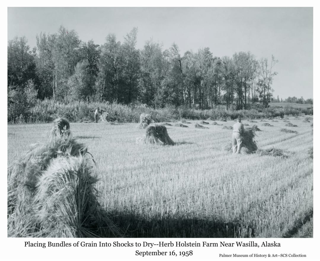
Farm 34
Cliff Marcus
Men gather harvested grain into shocks to dry
This photo shows two men gathering bundles of grain and standing them together into shocks with the heads at the top to dry. A completed shock is at immediate left foreground with three others in near middle ground while the two men are building others. Bundles of harvested grain awaiting the men's gathering activity lie on the stubble field that continues to the right out of the frame. An overgrown windrow from originally clearing the field and a large group of birch trees form most of the middle ground from the left, ending just short of the right side of the image, allowing a small view of another field beyond.
Matanuska Valley near Wasilla, Alaska
Farm 5
Cliff Marcus USDA Soil Conservation Service
Farming
Image shows a tractor pulling a grain binder in a grain field, cutting and bundling the grain, identified as barley. The foreground exhibits stubble where the grain had been cut, with numerous harvested bundles on the ground. One man is on the tractor, another on the binder at the edge of the uncut grain beyond. Roof tops of several buildings are visible beyond the grain field. Heavy forest is in background with clouds above. Location is identified as Art Thompson's farm on Scott Road just north of Palmer.
Palmer, Alaska
Farm 6
Cliff Marcus, USDA Soil Conservation Service
Farm
Image shows a summer season fenced in foreground with a farmstead in middle ground at the base of Bodenburg Butte. Mountains are in background. Caption: "Leonard William's farm. Brome fields with Bodenburg Butte in background."
Bodenburg Butte, Matanuska Valley, Alaska
Farming 14
T.H. Day USDA Soil Conservation Service
Farming
Image shows a man, identified as Max Sharrod, digging potatoes with his Ford tractor pulling a potato digger on his farm in north Palmer. Sharrod's house is visible behind two large cottonwood trees and a grain field is visible in middle ground. Trees, Talkeetna mountains and clouds are in the background.
Palmer, Alaska
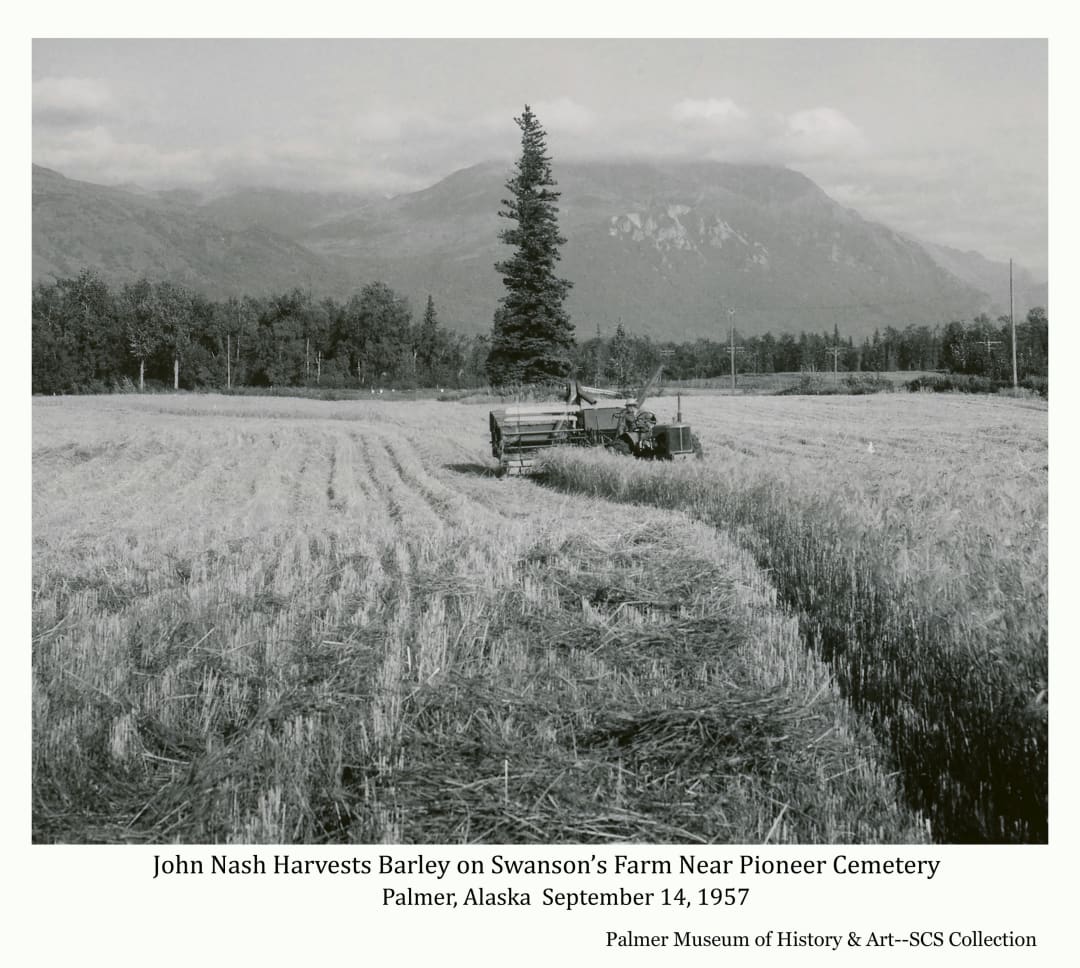
Farming 33
Cliff Marcus
Barley is being harvested with a combine in a field next to the Pioneer Cemetary in Palmer.
This fall image facing east shows local farmer John Nash combining barley in a field next to the Pioneer cemetery on the east side of Palmer. Much of the field has already been cut, with the tractor pulling the combine in the center of the image advancing toward the camera cutting a final strip of grain in the middle of the field. Remaining uncut grain is visible in middle ground at left. A tall narrow spruce tree stands obviously near the middle of the field directly behind the combine. Heavy birch forest forms the middle ground across the image with clouded-shrouded mountains occupying the near background. At the base of the trees just beyond the edge of the field at left several white gravestones are visible in the adjacent Pioneer Cemetary. At right are several power poles and lines paralleling the slightly visible Glenn Highway.
Palmer, Alaska
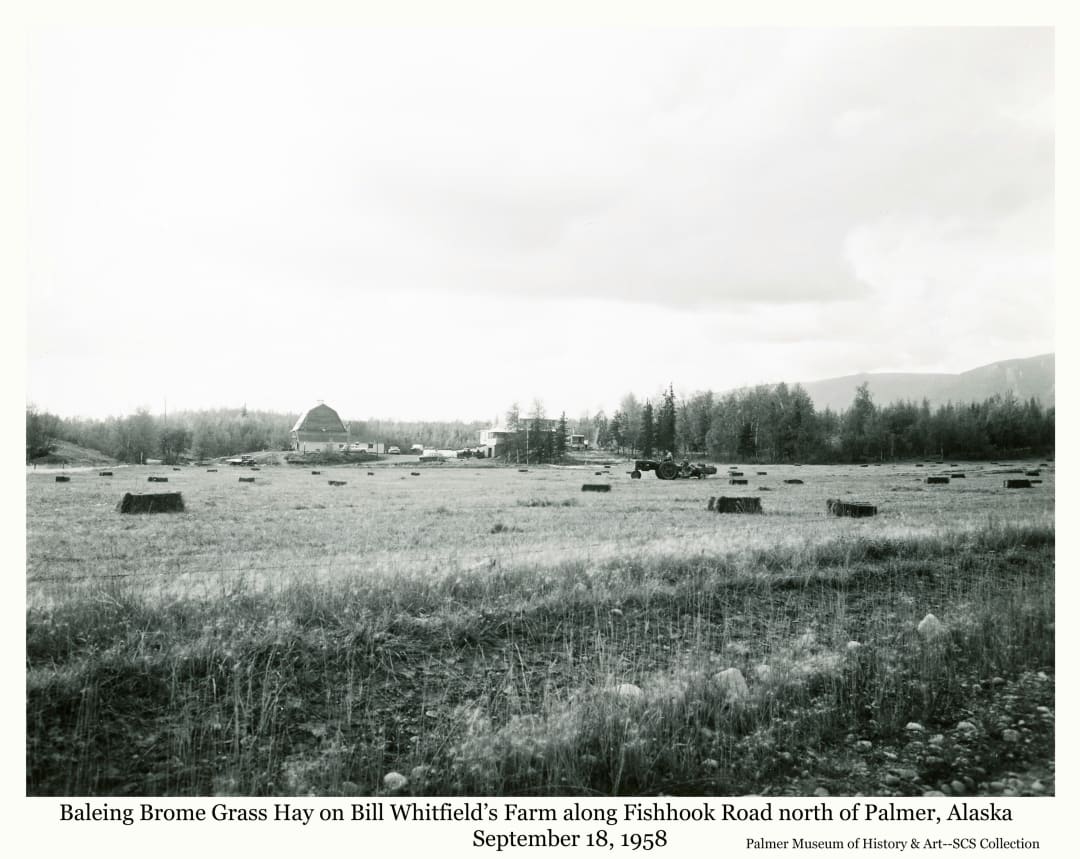
Farming 34
Cliff Marcus
Cut hay is being baled on the Bill Whitfield farm.
This photo, taken from the Palmer Fishhook Roadside, looks across a small field of harvested hay to a farmstead originally established by Matanuska Colonists Neil and Margaret Miller in 1935 on tract #155. The original barn and enlarged house are visible in left center middle ground on the far side of the field with heavy birch forest defining the field from the house to the right side of the image. A low wooded hill is visible behind the farmstead in the far middle ground. A low rounded mountain is partially visible at far right in background. Lying obviously on the foreground field are numerous rectangular ("square") hay bales with a man on a tractor near the center of the field pulling a baling machine as it picks up the loose cut hay and forms it into the bales and deposits them on the ground. At the time of the photo this working farm was also one of several Children's Homes in the Valley.
Matanuska Valley, Alaska
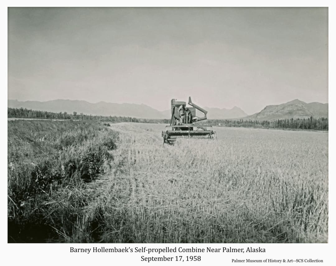
Farming 34
Cliff Marcus
Barney Hollembaek is harvesting a grain field near Palmer with his self-powered combine.
This north-facing image looks across a standing grain field located south of Palmer at a self-powered combine in center foreground as it approaches the camera. Two men are visible riding at the controls on the machine as it makes the second pass around the field. The photographer stands in the first swath cut at the left edge of the field bordered by tall weeds on the side of a road visible at far left. A thin strip of mixed forest lines the north side of the field and road across the image. Lazy mountain is apparent at far right in near background and Talkeetna Mountains are faintly visible at left and center in far background. This self-powered combine marks a significant evolution in grain farming in the Valley from the stationary threshing machines of earlier days and brought dramatic changes in the amount of work necessary to produce the grain.
South of Palmer, Alaska
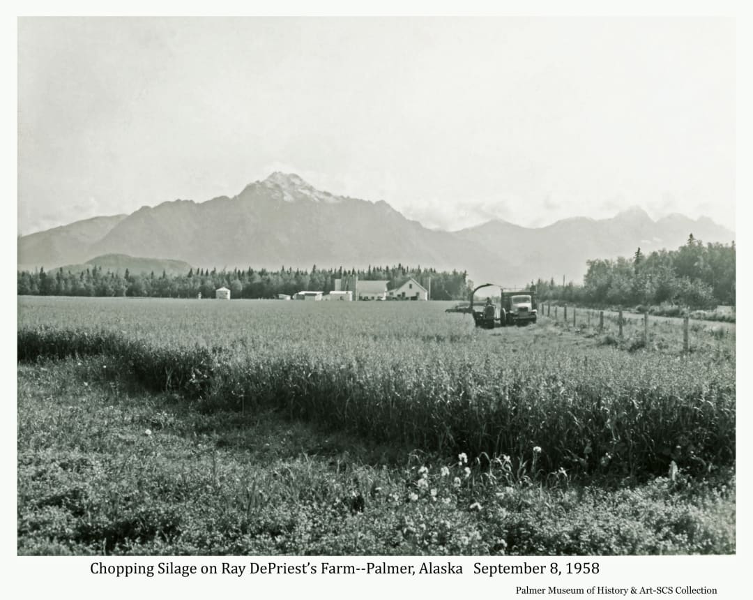
Farming 36
Cliff Marcus
A grain crop is being field chopped to be converted to silage for winter cow feed.
This photo shows a feed crop, probably oats and peas, being field chopped for silage. The north edge of the standing grain field is apparent in immediate foreground and stretches south to the farmstead in center middle ground. The white house, barn and several outbuildings, including at least three upright silos, are clearly visible. The field is bounded at right by a wire fence on wooden posts paralleling a visible road. An open-bed truck is seen to be proceeding toward the camera in parallel with the fence. Directly adjacent to the truck, at left in the image, is a mobile silage chopper machine being pulled by a tractor proceeding closely apace with the truck. As the grain is cut and chopped it is blown up the visible arched pipe and can be seen being blown into the bed of the truck. The chopped material will be delivered to the silo and dumped into a stationary machine that will blow it up a pipe into the top of the silo. Behind the farmstead and the road at right, dense mixed forest is apparent in middle ground. The top of Bodenburg Butte is visible in near background at left while Pioneer Peak and associated Chugach mountains are obvious in far background. A dusting of snow is visible atop Pioneer Peak.
Near Palmer, Alaska
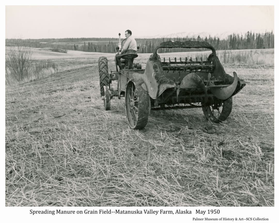
Farming 38
Ray Kent
A farmer is spreading manure on his field with a manure spreader machine.
This spring photo shows a farmer on his tractor in foreground pulling a manure spreader away from the camera on a stubble field resulting from a previous year's grain harvest. Accumulation of animal manure at the farmstead is loaded into the bed of the machine and hauled to the farm field. There, gears are engaged to activate an endless chain in the machine's bed to move the material to the back where the visible shredder teeth and spinning spiral bar spread the nutrient-rich waste widely on the field, returning the valuable fertilizer to the soil to feed the next crop. The gently rolling cleared field stretches beyond the tractor into the middle ground bounded by mixed spruce /birch forest beyond. A low rounded hill is visible in near background with snow-covered mountains slightly visible in far background at right.
Matanuska Valley, Alaska
Grain Dryer
Cliff Marcus, USDA Soil Conservation Service
Farm
Image shows a collection of structures including a large metal container with an exhaust tube and fan. A high-sided truck is backed up to the structures. A fuel barrel on a stand is evident, as is a power pole and power lines near a wooden shed. Location is identified as the Barney Hollembaek farm south of Palmer. Mountains are in background.
Palmer, Alaska
Matanuska Valley Air View 5
T.H. Day, USDA Soil Conservation Service
Matanuska Valley
Image is an oblique aerial view looking northwest across the Matanuska Valley with the braided channel of Matanuska River in foreground. The City of Palmer, Palmer Airport, and surrounding farms are evident beyond the river. Land clearing patterns are apparent. Talkeetna Mountains are in background.
Palmer, Alaska
Max Sherrod and vegetables
Lew Hanks, Soil Conservation Service
Max Sherrod packing vegetables for shipment to market
Image shows Palmer farmer Max Sherrod in his packing shed preparing and crating vegetables for shipment to market. Vegetables shown include carrots, cauliflower, and lettuce. This produce was grown with the aid of irrigation.
Palmer, Alaska
Mine 3, Independence
Cliff Marcus, USDA Soil Conservation Service
Mine
Image is a southerly view of a mountain valley containing numerous buildings associated with the Independence Gold Mine. Several vehicles are visible. A small stream is evident as are roads leading up to the mine and to Hatcher Pass on the right. The photo was taken from the area developed for skiing at the time.
North of Palmer, Alaska
Palmer Air View 8
T.H. Day, USDA Soil Conservation Service
Matanuska Valley
Image is an oblique aerial view looking northwest across the Matanuska Valley with the City of Palmer in foreground. The fairgrounds and surrounding farms are evident. The Glenn Highway passing through Palmer, and the Palmer-Wasilla Road are evident. Land clearing patterns are apparent. Talkeetna Mountains are in background.
Palmer, Alaska
Palmer Street 14
USDA Soil Conservation Service
Palmer
Image shows a winter scene looking north along Alaska Street from the sidewalk in front of the 49 Club Bar. The bar sign is prominent as is a sign for Charlie's Bar B-Q. Blowing snow is evident. Plowed snow berm at the sidewalk is prominent. Three people are visible and several automobiles. The railroad depot is in middle ground as is the co-op garage, water tower, powerhouse, and a flatcar on the tracks. Talkeetna Mountains are in background.
Palmer, Alaska
Sawmill 3
Lew Hanks-USDA Soil Conservation Service
Sawmill
Image shows a man, identified as Bob Welch, standing next to a portable sawmill in a birch forest setting. The mill carriage and circular saw blade are obvious. A stack of lumber is evident in foreground and logs to be sawn are visible. Two fuel barrels are evident, one with a pump attached. Background is composed of a forest stand. largely composed of slender birch trees. Information associated with the photo indicates this was the only operation in Alaska specializing in producing birch lumber at the time.
Near Knik, Alaska
Sawmill 9
Unknown
The sawmill at Wasilla established to mill Valley cottonwood logs for export
Image is of the Wasilla sawmill established in the 1950’s to mill cottonwood logs for export. It was located in East Wasilla, below the hill later occupied by the Home Depot store, next to the railroad tracks visible in foreground.
Wasilla, Alaska
SCS Personnel 1
Ray Kent
Palmer SCS staff in 1953
Image is of the Soil Conservation Service staff at the Palmer office posing in front of a car.
Palmer, Alaska
SCS Personnel 10
Cliff Marcus
SCS soil scientist Dale Schoephorster ("Shep") works at his desk in the Palmer office.
This image shows SCS soil scientist Dale B. Schoephorster in center foreground, seated facing to the right on his typical government issue wooden desk chair, at his typical government issue metal desk in the Palmer office. On the desktop is a typical government issue articulated-arm desk lamp and typical government issue two-tier metal desk in basket. A typical government issue trash can is apparent next to the desk in immediate foreground. Wood grain wainscoting covers the lower wall at Dale's immediate left with large maps covering the wall above.
Palmer, Alaska
SCS Personnel 11
Cliff Marcus
Soil scientists Bobby Hinton and Dale Schoephorster finalize their inventory maps and write reports at the end of a summer's soil inventory work in the field.
This photo shows soil scientists Bobby Hinton, at left, and Dale Schoephorster, at right, seated at their desks in foreground facing toward the wall with their backs to the camera in their office in the Severns Building in Palmer. They sit on different style wooden desk chairs, Hinten at a wooden desk, Schoephorster at his metal desk. A four-tier metal filing cabinet separates the desks, and a metal trash can sits on the floor between them. Wainscoting covers the lower wall directly in front of them and two large Alaska maps are on the wall above.
Palmer, Alaska
SCS Personnel 12
Soil Conservation Service
District Conservationist Cliff Marcus takes a core sample from a birch tree to determine the age of the surrounding stand of trees.
This image shows District Conservationist Cliff Marcus taking a core sample of a birch tree to determine the age of the trees growing in the area. The cross-section sample extracted from the tree with the coring tool exposes the annual growth rings which are counted to determine the age of the tree. The stand of trees in view appears to be a mixture of birch and spruce with most of the birch trees being younger than the one Cliff is aging.
Unknown
SCS Personnel 2
Charles Wilson, Soil Conservation Service
SCS Staff at Palmer, summer 1958
Image shows the Soil Conservation staff at Palmer during the summer of 1958 posing in front of the Palmer office at S. Alaska Street & W. Dogwood Ave. Identified as (l to r): Flavia Marcus, Wanda Somerville, Dupree Sanders (detailed from Texas), James DeMent (detailed from Louisiana), Allan Linn, Edna Wehking, Sam Rieger, Cliff Marcus. Not shown is Charles Willson who took the picture. The two detailers were here for the season to conduct soil surveys.
Palmer, Alaska
SCS Personnel 3
T.H. Day
Cliff Marcus, Conservation Surveyor, evaluates a soil sample as he maps an area’s soil types
Image shows Conservation Surveyor Cliff Marcus, evaluating a soil sample he has extracted with his auger as he maps soil types on the Kenai Peninsula. Cliff worked out of the State Soil Conservation Service office in Palmer for many years, traveling to various areas of the state to identify and map the soils for their agricultural potential.
Kenai Peninsula, Alaska
SCS Personnel 4
Art Hawk, Soil Conservation Service
Soil scientists evaluate a soil sample
Image shows three men, identified as soil scientists (l to r) Bobby Hinton, Dr. Sam Rieger, and Frank Carlisle, inspecting a soil sample drawn from the ground by a soils probe tool. Headquartered in Palmer, they were reviewing soils surveyed and mapped on the Kenai Peninsula. The soil survey is the basic tool of land-use planning in Alaska. SCS technicians use the survey to advise homesteaders on which land is most suitable to clear and the best use for each soil type on the homestead.
Kenai Peninsula, Alaska
SCS Personnel 5
Lew Hanks
Conservationist Lew Hanks consults with farmer LaRose
District Conservationist Lew Hanks reviews a land use map with Matanuska Valley farmer and Colonist Henry LaRose during the winter of 1953. Temperature was noted to be minus 30 degrees.
Matanuska Valley, Alaska
SCS Personnel 6
Cliff Marcus
Pat Scheibl, Matanuska "Colony Kid", finds work soon after high school graduation as clerk-typist with the USDA Soil Conservation Service State office in her hometown.
USDA Soil Conservation Service employee Pat Scheibl smiles from her desk in the agency's State headquarters office in Palmer where she was employed as a clerk-typist. Office furniture in her corner workspace includes a typical government wooden desk with desktop florescent articulated lamp, a modern electric typewriter (barely visible behind her), a tabletop office machine (printer?) under an opaque plastic cover atop a small dark table at the photo's left, and a modern style padded guest chair partially visible at extreme left. On the wall above her desk at right is a large poster illustrating "How Grass Makes Food For Growth" and a large map of Alaska is partially visible high on the wall at left. Pat is a longtime resident of Palmer, having arrived in 1935 from Wisconsin with her Colonist family participating in the government's Matanuska Colony Relocation Project.
Palmer, Alaska
SCS Personnel 7
Unidentified
Clerk-Typest Pat Scheibl is working in the SCS office in Palmer.
Clerk-Typest Pat Scheibl works facing the camera at her desk in the State Soil Conservation Service Office in Palmer. Her typewriter and various desk-top material are before her in foreground. A rack of various publications is on the wall behind her. The views through two windows behind her show the sign on the Frontier Cafe at left and the back of the Wright Building across the street out the right window, confirming that the office in which she is working is in the Severns Building at the corner of W. Evergreen Ave. and S. Bailey Street.
Palmer, Alaska
SCS Personnel 8
Lew Hanks
Most of the Palmer staff of the Soil Conservation Service gather for their group photo in 1956.
This photo shows most of the staff of the USDA Soil Conservation Service in their office at S. Alaska Street and W. Dogwood Ave. in Palmer. Names of all but one man are identified on the photo caption. Lew Hanks, District Conservationist, took the picture and is not shown. The people are standing behind a standard government office desk and chair with Alaska maps and a large twelve-month calendar dated 1956 behind them on the walls.
Palmer, Alaska
SCS Personnel 9
Lew Hanks
The Palmer SCS staff gather for the presentation of a 10-year service award to Conservation Surveyor Cliff Marcus. s.
This photo shows most of the USDA Soil Conservation Service personnel who worked in the Palmer office at S. Alaska Street & W. Dogwood Ave. in 1959. Lew Hanks, District Conservationist took the photo and is not shown. The group is gathered in the corner of an office behind a standard government wooden desk and chair for a presentation of a 10-year service award to Cliff Marcus. Large Alaska maps and a large 12-month calendar are posted on the walls behind them.
Palmer, Alaska
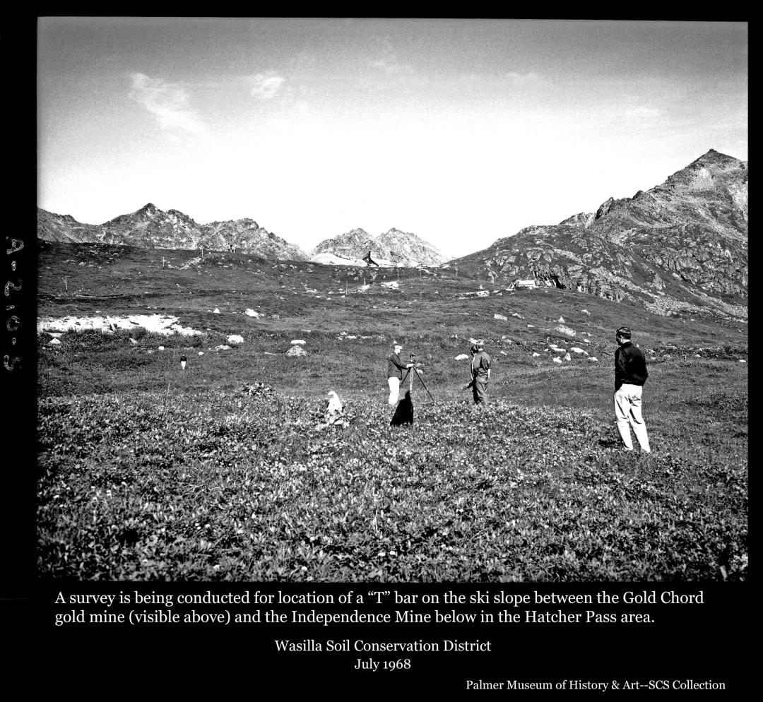
Ski Hill 1
Cliff Marcus
Surveyors map the potential ski hill between Independence Mine and the Gold Cord Mine in the Hatcher Pass area of the Talkeetna Mountains north of Palmer, Alaska.
This summer photo, taken from the hill just north of the Independence Mine complex near Hatcher Pass, and looking up at the Gold Cord mine, shows several people in the process of surveying the intervening slope in preparation for installing a "T" bar ski lift. This ski hill, with facilities operated from some of the Independence Mine buildings remaining after mining activities ceased, provided the only developed downhill skiing opportunities in the Valley for many years in the 1960's.
Hatcher Pass area north of Palmer, Alaska
Snow Survey 1
Joe Dwyer
A technician weighs a snow sampling tube filled with a snow core sample in preparation of calculating the water content of the snow.
This winter photo shows a man in foreground, identified as Andrew Linn, standing in a large snowy expanse on snowshoes weighing a sampling tube which has previously been driven vertically into the snow and now contains the snow core which filled it. The extracted tube hangs horizontally on scales attached to a small scrubby spruce tree extending a few feet above the snow. Mr. Linn, dressed in an insulated hooded coat, is bent over looking at the reading on the scale and is holding a notebook in his hand. Scattered spruce forest appears out of focus at the base of a barely visible mountain in background.
Indian Pass Snow course, Ship Creek Watershed
Snow Survey 2
Joe Dwyer
A technician weighs the empty snow sampling tube to establish reference data for calculating water content of the snow pack.
Technician Andrew Linn, at left foreground in this winter photo, is crouched down to read the weight of a long, empty snow sampling tube hanging horizontally on scales attached to a scrubby spruce tree extending several feet above the snow. Knowing the weights of the tube when empty and when filled with a snow core sample was critical in calculating the moister content of the snow. A group of spruce trees exhibiting a wind-blown or alpine influenced character are obvious in middle ground with a diamond-shaped snow course sign attached high up on one. The sign acknowledges the Federal-State cooperative nature of the snow surveys. A partly tree-covered hill and faintly visible mountain are seen in background.
Ship Creek Watershed, Alaska
Snow Survey 3
T.G. Freeman
Scientists from the Soil Conservation Service and US Geologic Service gather snow-related data from nearby sample plots in the Ship Creek Snow Course and sharing cost of necessary helicopter access.
This image shows a man, identified as USGS scientist W.W. Barnwell, crouched on his snowshoes in immediate foreground in a large snow-covered expanse covering the rest of the foreground of the image. Wearing a quilted coat and dark winter hat with a camera hanging from his neck, his attention is focused on a small metal box balanced on his knees with its top cover open exposing a surface with a meter and several dials. Wires lead to an exposed pipe protruding about 20 inches above the snow surface close in front of him. A shorter exposed section of pipe is visible at left. The caption identifies that he is recording conditions of soil moisture below the snow cover. Scattered trees are apparent in middle ground with a helicopter parked in an opening beyond. Scattered trees cover the base of a mountain beyond in near background.
Ship Creek Snow Course
Snow Survey 4
Ted Freeman
Establishing a snow survey data collection site in summer allows construction of facilities such as this snow depth indicator that will later be necessary when the site is covered in deep snow.
Part of the mission of the Soil Conservation Service in Alaska is to gather data related to winter snow accumulation and condition in various locations as a historical record and for use in understanding potential water runoff when the snowpack melts in the coming summer. This summer photo shows one of the permanent sites chosen where winter visits by SCS scientists and others will collect data about the snowpack conditions. Set amongst brush in foreground is a ladder-like structure with five small boards attached at about three-foot intervals to a pole approximately 15 feet tall. This structure is assumed to aid in determining snow depth at the time of later winter visits. Scattered spruce trees are apparent throughout the middle ground with rounded hills and low mountains in background.
Near Mt. Fairplay along the Taylor Highway
Snow Survey 5
Tom Freeman
Buddy "Bud" Woods of Palmer waits with his airplane for the scientists he has flown to the Black River to complete their work setting up a snow course site.
Establishing permanent sites for gathering data on snow depth and condition throughout Alaska usually involved summer installation and maintenance of some material or structures that would be needed in place when data was later to be collected when the site was covered in deep snow. This photo shows a large white amphibious "Widgeon" airplane resting on a gravel bar in foreground next to the Black River seen in front of the plane in near middle ground. A heavy spruce forest covers the middle ground from the far riverbank blocking all behind it but a small view of a low hill in background at left. Standing atop the plane is pilot Buddy "Bud" Woods of Woods Flying Service in Palmer, inspecting and maintaining his aircraft as he awaits return of the scientists he has flown to this location of a snow course site.
Black River, Alaska
Snow Survey 6
T.G. Freeman
Buddy "Bud" Woods awaits return of scientists he has flown to the area to establish or maintain a snow course survey site.
This summer photo shows Buddy "Bud" Woods, of Woods Flying Service of Palmer, in foreground standing in Deadman Lake, fishing, with his "Widgeon" amphibious airplane floating in the water behind him. On the shoreline across the lake to the left middle ground a small cabin is visible. A low rounded, treeless mountain stands at left and center in near background.
Deadman Lake, Alaska
Snow Survey 7
Tom Freeman
Buddy Woods points to where a bear has scratched high up on the tree bark in past years as it tore down the official snow survey site marker.
This photo, taken at the heavily forested Black River snow course site, shows snow survey assistant Buddy "Bud" Woods standing below a large cottonwood tree with brush on the ground and heavy cottonwood forest taking up the rest of the image. He's holding up a machete in his outstretched hand pointing it up at a high mark on the tree at which a bear has scratched the bark. Somewhat above the scratch marks is an official "Snow Course Marker" sign proclaiming this as a special government use spot. Apparently, the resident grizzly bear took exception to this claim as indicated by the official note associated with the photo: "Woods pointing to the high claw mark made by a big bear. Each year the bear destroys the snow course marking sign and puts claw marks higher to show how big he is. This time the sign was placed as high as we could reach by one man standing on the shoulders of the other. If the bear makes marks above this one he can have the territory."
Black River, Alaska
Soil Erosion 1
Lew Hanks
Wind erosion of frozen soil
Image shows wind erosion of frozen roadside soil exposing stumps of trees previously buried by air-born soil deposited by winds off of the Matanuska River out of view to the left.
Palmer, Alaska
Soil Erosion 3
Lew Hanks
Local wind has blown away enough topsoil from an onion field to leave the unharvested onions exposed on top of the remaining soil.
This mid-winter view of an unharvested onion field shows mature onions lying on top of the ground in foreground and several rows of exposed onions running diagonally from left to right into the middle ground. A low broadleaf tree-covered hill is visible out of focus in middle ground at upper left. The onions becoming exposed results from the top layer of bare soil being blown away by local Matanuska Valley winds.
Matanuska Valley, Alaska
Soil Erosion 4
Tom Day
Unharvested potatoes lie on the surface of a field having been exposed by winds blowing away the soil that had covered them as they grew.
This winter view shows a field of exposed soil in foreground and near middle ground with a low ridge of soil running across the frame in middle ground with a leafless tree and minor brush on top. The field exhibits scattered dead potato roots and numerous unharvested potatoes lying on the surface, exposed by local winds having blown away the soil which once covered them as they grew.
Matanuska Valley, Alaska
Soil Erosion 5
T.H.Day
Lettuce roots left behind in the soil after the above-ground crop was cut now extend as much as four inches above the field's surface indicating how much soil has been blown away since the fall harvest.
This winter image shows a field of bare soil with numerous rows of what are identified as lettuce roots standing up to four inches above the soil surface. The rows run from lower right foreground to upper left middle ground. A low brush-covered ridge holding small patches of snow crosses the image in far middle ground. When lettuce is harvested it is normally cut at ground level below the head or leaves. The roots are thus left in the ground. The exposed roots in this photo illustrate the depth of soil that has been blown away since the fall lettuce harvest.
Matanuska Valley, Alaska
Soil Erosion 6
Tom Day, USDA Soil Conservation Service
Farming
Image shows a winter scene of several carrots in foreground sticking up from the soil indicating wind eroded the soil from around them. A black hat is nest to the carrots for scale. A typical Colony barn is in background across a barren field. Patches of snow are evident in the background.Farm identified as that of Al Saxton.
Two miles north of Palmer, Alaska
Sprinkler Irrigation
Cliff W. Marcus, USDA Soil Conservation Service
Farming
Image shows a grass field with a pond in foreground. A farm tractor, pump and pipes are at the edge of the pond. A man attends the tractor with a pickup truck behind. A collection of barns, houses, silos, and Quonset huts are in background at the edge of the forest. Caption: "Pumping equipment and sprinkler system from pothole. Leonard Moffitt farm."
Near Palmer, Alaska
