

Ruth (DeArmond) Estelle arrived in Palmer in 1936 as the Extension Service "District Home Demonstration Agent" to assist the women and children of the Valley in adjusting to Alaska living and generally to help them improve their lives. Planning nutritious family meals, canning salmon and smoking moose meat, cutting patterns and sewing clothes, gardening, and a wide array of 4-H projects were all activities of which she provided instruction and assistance. Ruth was very involved with the social life of the new community and recorded many aspects of that life with her camera. The collection includes 430 images gathered by Ruth, as well as photos contributed by other members of the family.


4-H Club Float 1
Hewitt's Photo Shop, Anchorage
4-H People
Image shows a side view of a pickup truck with several children standing in the back facing the camera. One girl holds a large paper star. A sign on the side of the truck shows the 4-H clover leaf symbol and text: "4H CLUBS-IN-VALLEYS: 5, ENROLLMENT: 85". A spare tire is prominently mounted on the side of the truck. The driver, identified as Howard Estelle, and passenger, identified as Ruth DeArmond, are visible in the truck cab.
Palmer, Alaska
4-H Club Girls
Ruth Estelle
People
Image shows a group of young girls standing together in front of a wooden building. The group is identified as "Colony Kids" making up a 4-H Club. A white tent is visible in the background. One adult, identified as Mrs. Ring, is in the back row, center. Some others are identified as: Genevieve Ring, June Lentz, Jean Mae Sandvik, June France Leila Peterson, Lucille Ring, Jean Kindgren, Pat Hemmer, and Pat Ring.
Palmer, Alaska
4-H Club Meeting
Ruth Estelle
People
Image shows a group of young girls and two women seated on logs in a wooden setting. One girl, identified as Genevieve Ring, is standing and appears to be leading the group in some activity. Two women are seated with the group, identified as Ruth Peck on the left and Ruth DeArmond on the right of the photo.
Palmer, Alaska
4-H Sewing Club
Ruth (DeArmond) Estelle
People
Image shows four girls and one women in white dresses sitting on the porch of a log cabin, each appears to be stitching a piece of cloth. The group is collectively identified as the Butte 4-H Sewing Club and individually identified from left as: Barbara Falk, Lila Peterson, Dorothy Newville, Patty Hemmer, and the woman is identified as Lila Newville, the club leader.
Bodenburg Butte Area, Matanuska Valley, Alaska
Bridge-Knik 78
Ruth DeArmond
The recently constructed Knik River bridge is viewed from up on the side of Pioneer Peak.
This photo features the recently completed Knik River highway bridge southeast of Palmer. It is taken from up on the side of Pioneer Peak on the south side of the river. The lower right foreground portion of the image is very dark, but close examination reveals a strip of loose gravel suggesting the photographer likely climbed up one of the mountain's slide areas. The rest of the dark area represents the heavily forested mountainside, cut by a short section of the Palmer/Anchorage Road barely visible below near the water. The wide Knik River occupies a center third of the image diagonally from upper right to lower left with the multi-span steel bridge crossing the apparently white water. The lowlands on the far side of the river appear as unbroken forest from the river to the base of mountains in the background.
Knik River, Alaska
"Brill Car"
Ruth Estelle
Railroad Car
Image shows the McKeen Motorized Rail Car, locally called the "Brill car" or "Brill Train", on the Palmer siding. This car ran daily between Palmer and Anchorage for several years, hauling passengers and freight.
Palmer, Alaska
Butte Community Hall 3
Ruth Estelle
Building
Image shows the north side of the log Butte Community Hall with lumber and clearing debris in foreground and Pioneer Peak in background.
Bodenburg Butte Area of Matanuska Valley, Alaska
Bygone Barn 1
Richard Estelle
Colony barn in state of collapse
Image is a winter view of a Colony Barn, identified as located on Tract#157 near Bodenburg Butte and having originally belonged to Colonists Lawrence and Grace Dreghorn. The barn exhibits evidence of early stages of collapse. A smaller structure, possibly a chicken coop, is apparent at left and a pick-up truck is parked in foreground. Pioneer Peak is the backdrop.
Bodenburg Butte, Matanuska Valley
Bygone Barn 2
Richard Estelle
Colony barn in state of collapse
Image is a summer view of a Colony Barn, identified as located on Tract #134 north of Palmer, having originally belonged to Colonists Oscar and Elvi Kerttula. The barn exhibits significance evidence of advanced stages of collapse and came down in 2006. A smaller attached structure, perhaps a milking parlor, is at right and a concrete upright silo is behind at left.
North of Palmer, Alaska
Bygone Barn 3
Richard Estelle
Colony barn in state of collapse
Image is a summer view of a Colony Barn, identified as located on Tract #134 north of Palmer, having originally belonged to Colonists Oscar and Elvi Kerttula. The barn exhibits significance evidence of advanced stages of collapse and came down in 2006. A smaller attached structure, perhaps a milking parlor, is at right, Talkeetna Mountains evident in background.
North of Palmer, Alaska
Bygone Barn 4
Richard Estelle
Colony barn in state of collapse
Image is a summer view of a Colony Barn, identified as located on Tract #134 north of Palmer, having originally belonged to Colonists Oscar and Elvi Kerttula. The barn exhibits significance evidence of advanced stages of collapse and came down in 2006. A smaller attached structure, perhaps a milking parlor, is at right, part of another smaller log structure, perhaps a chicken coop, is at left, and a concrete upright silo is behind at left.
North of Palmer, Alaska
Bygone Barn 5
Richard Estelle
Colony barn in state of collapse
Image is a fall view of a Colony Barn, identified as located on Tract #194 near Bodenburg Butte, having originally belonged to Colonists Lloyd and Dorothy Bell. The barn exhibits significance evidence of advanced stages of collapse. Portions of other buildings are evident adjacent and nearby, Beyers Peak is in background. This farm, located at the corner of Bodenburg Loop Road and Doc. McKinley Ave., was later owned by dentist Lee McKinley prior to the later demise of the barn. This photo is number one of three documenting the collapse of this barn.
Near Bodenburg Butte, Alaska
Bygone Barn 6
Richard Estelle
Colony barn in state of collapse
Image is a summer view of a Colony Barn, identified as located on Tract #194 near Bodenburg Butte, having originally belonged to Colonists Lloyd and Dorothy Bell. The barn exhibits significance evidence of advanced stages of collapse. A portion of an attached concrete block building is evident at left. Bodenburg Butte is behind. This farm, located at the corner of Bodenburg Loop Road and Doc. McKinley Ave., was later owned by dentist Lee McKinley prior to the later demise of the barn. This photo is number two in a series of three documenting the collapse of this barn.
Near Bodenburg Butte, Alaska
Bygone Barn 7
Richard Estelle
Colony barn in state of collapse
Image is a summer view of a Colony Barn, identified as located on Tract #194 near Bodenburg Butte, having originally belonged to Colonists Lloyd and Dorothy Bell. The barn is in final stages of collapse. A portion of an attached concrete block building is evident at left and Chugach Mountains are in background. This farm, located at the corner of Bodenburg Loop Road and Doc. McKinley Ave., was later owned by dentist Lee McKinley prior to the later demise of the barn. This photo is number three in a series of three documenting the collapse of this barn.
Near Bodenburg Butte, Alaska
Bygone Barn 8
Richard Estelle
The old log hay barn, with several large holes in the roof, stands unused and falling into disrepair.
Image is of an old log hay barn, two bays with a drive-through in between. The pitched roof is partly covered with sheet metal with several pieces missing, exposing the log stringers underneath. The side of the left bay is also covered with sheet metal. A doorway is visible on the interior wall of the right bay and a window hole is apparent on the north wall of the right bay. Low brush is in foreground, broadleef trees and part of a field are behind the barn.
Beside Fishhook Road north of Palmer, Alaska
Cabin 4
Ordway
Building
Image is a winter scene of a log cabin in foreground with snow on the ground and roof. A rail frame fence is adjacent with mixed birch and spruce forest behind. Mountains form the near backdrop with a conical peak prominent, variously identified over the years as "The Matterhorn", Beyers Peak, and Matanuska Peak. Other photos in the collection indicate the fenced area was probably fox pens. An associated cache was located in front of the cabin closer to the Matanuska River, The road that developed between Palmer and the Bodenburg Butte area passed between the cabin and cache. The cabin is believed to have belonged to Eugene Marsh.
Palmer, Alaska
Cabin 6
Unknown
Trapper’s log cabin near Palmer
Image is a summer view of a log trapper’s cabin located on the north side of Matanuska River east of Palmer. The mountain beyond has been known variously as “The Matterhorn”, “Beyers Peak”, and “Matanuska Peak”. The cabin is thought to have belonged at one time to Eugene Marsh.
Near Palmer, Alaska
Cabin 7
Ruth DeArmond
Trapper’s cabin & Cache along the Palmer to Anchorage Road near Palmer is the same one as seen in "Cache 1, 5 and 6".
Image is a winter view looking north along the snow-covered Palmer to Anchorage road about a mile east of the Matanuska River bridge. Shown is a log cabin, fox pens, and another small structure on the north side of the road and a cache on the south side. Heavy birch and spruce forest is the backdrop of the clearing with snow-covered Talkeetna Mountains visible in background beyond the cleared roadway.
Near Palmer, Alaska
Cache 3
Hewitt's Photo Shop
A raised cache formed with sawn boards stands ready to store important goods for a settler or trapper, safe from the weather and wild animals.
Image is of a fairly typical elevated cache, raised on four upright cottonwood posts to a height of 15 feet or so, with a pole platform to support the plank "house" on top. The pitched roof appears to be of boards with roofing paper covering.
Alaska
Cache 4
unknown
A raised cache formed with small logs stands ready to store important goods for a settler or trapper, safe from the weather and wild animals.
This photo of an old "trapper's cabin" in foreground set in a clearing of thin spruce and cottonwood forest visible behind it. Stumps, logs and cut brush litter the immediate foreground. The cache itself is composed of small logs, with a pitched roof of planks, set on a platform of small logs. The structure is supported by four slender poles approximately 20 feet high. The small size of the supports and lack of stabilizing bracing indicate it is to be a somewhat temporary structure. Lack of typical sheet metal armor on the supports to deter climbing animals may also indicate that construction is not quite complete. The access ladder is visible lying at right, propped up on a cottonwood log to keep it off the wet ground.
Alaska
Cache 5
Ruth DeArmond
A log trapper's cache stands beside the road between Palmer and Bodenburg Butte, approximately a mile past the Matanuska River bridge. This cache was associated with the log cabin directly across the road as seen in photo "Cabin 7" and is the same on in photos "Cache 1 and 6"
This photo shows a log trapper's cache in foreground consisting of a small cabin-like structure approximately 8' x 10' in size standing on four vertical posts approximately 12 feet above the ground. It stands at the far edge of a road cut in near foreground. At left is a large, tall cottonwood tree with a deformed top. Behind the cache in middle ground is a brushy forest of mixed spruce, alder and cottonwood trees.
Approximately a mile East of Palmer, Alaska
Cache 6
Hewitt's
This trapper's cache stood next to the road between Palmer and Bodenburg Butte approximately a mile east of the Matanuska River bridge and is the same one visible in photos "Cache 1" and "5", and "Cabin 7."
This photo shows the back side of a log trapper's cache standing in foreground at the edge of a gravel road. The cache is a cabin-like structure approximately eight feet wide set atop four vertical posts approximately 12" high. This summer view shows a large cottonwood tree at far right standing above a heavy alder and cottonwood forest in middle ground at right. The light-colored road enters the image at lower left and is visible through the legs of the cache and beyond as it curves out of sight to the right in middle ground. A high brush field lies on the far side of the road with tall mixed forest beyond in background. The shoulder of a mountain is faintly visible at far left in background.
East of Palmer, Alaska
Chickaloon Coal Mines
Keystone View Company
View of Chickaloon coal mining community
Image shows a man standing in foreground near the mouth of a mine tunnel structure. Rail tracks used by mine cars accessing the tunnel are evident. Lumber and logs are stacked nearby. In middle ground a train with several passenger cars is apparent on the flat land below, as well as numerous large and small buildings. Power poles are evident near the train and at the mine mouth. The community is located on the Chickaloon River floodplain with steep bluffs rising on both sides topped with heavy forest. Mountains are faintly visible in background.
Chickaloon, Alaska
Church 14
2nd Mapping Squadron, U.S. Army Air Force
Eklutna Russian Orthodox church and burial houses
Image shows a springtime view of several Native burial houses in foreground, a log Russian Orthodox church in middle ground, trees and snow-clad mountains beyond.
Eklutna, Alaska
Church 17
Unknown
United Protestant Church in Palmer
Image is a summer view of the west side of the United Protestant (Presbyterian) Church in Palmer as seen from S. Denali St. The associated Manse is visible at right.
Palmer, Alaska
Church 18
Unknown
Pastor’s Residence, or Manse, United Protestant Church in Palmer
Image is a summer view of the Pastor’s residence, or “Manse”, associated with the United Protestant (Presbyterian) Church in Palmer.
Palmer, Alaska
Church 21
Unknown
The interior of the log United Protestant Church in Palmer displays why the building is often called "The Church of a Thousand Trees."
This photo shows the interior of the United Protestant Church in Palmer soon after it was constructed in 1937.
Palmer, Alaska
Church 22
Moore's Photo
Comparison of this photo with photo "Church 21" shows a maturing commitment of the congregation toward their church.
This photo of the interior of the Palmer United Protestant Church sanctuary shows improvements made by the mid 1950's since initial construction in 1937. Upgrades include addition of an electric organ, new pews, new pulpit and chandeliers.
Palmer, Alaska
Church 23
Unknown
The choir loft and pulpit stand ready for services at the head of the sanctuary in the United Protestant Church in Palmer.
This photo shows a foreground view of the alter table, pulpit and choir loft of the United Protestant Church in Palmer. Reflecting the nickname "Church of a Thousand Trees", the back wall, sides and front dividers of the choir loft exhibit the log character of the rest of the church. A framed cross on the back wall at the peak of the loft is also constructed of small logs. The small table in near foreground and the pulpit behind were crafted by local craftsmen from local trees as well. Carved on the front panel of the table are the words "In Remembrance Of Me". A white vase of flowers sits atop the table with two wooden offering plates stacked on either side.
Palmer, Alaska
Church 24
James W. Mordecai
Long-time caretaker of the old Eklutna Russian Orthodox Church, Mike Alex, stands proudly in front of the colorful religious trappings inside the building.
This color image of the interior of the old Russian Orthodox Church in Eklutna shows the colorful front panels, paintings and other objects in the building. Wheat-colored fabric covers the walls and ceiling, held in place with wooden strips. Rugs on the wooden floor lead up to the alter where the alter cloth exhibits a black image of the Orthodox cross. A local man, identified as Mike Alex, dressed in light tan jacket and pants, stands facing the camera at left. Mr. Alex is identified as caretaker of the church for many years.
Eklutna, Alaska
Church 25
James W. Mordecai
Caretaker Mike Alex stands proudly inside the new Russian Orthodox Church he helped build in Eklutna, Alaska.
Mike Alex, caretaker of this Eklutna Russian Orthodox Church, stands at the front of the church interior surrounded by religious symbols and ceremonial structures. Gold crosses, paintings and tapestries stand in front of a partition wall accessed by three doors behind Mr. Alex. A rectangular gas stove is visible at left, an accommodation for winter services. No benches or pews are in evidence as most attendees stand during services.
Eklutna, Alaska
Church 26
Unknown
Eklutna's Historic Park provides visitors with a view of their old log church, their new church and the cemetery with its colorful small "spirit houses".
This summer color photo of a portion of Eklutna Village's Historical Park shows several small colorful traditional grave houses, or "spirit houses" as they're sometimes called, in foreground. The old log St. Nicholas Orthodox Church is seen in middle ground at left with the new white church constructed in 1962 slightly behind and to the right. A small brown shed of indeterminate purpose sits next to a large birch tree somewhat between the two churches. Heavy deciduous forest occupies the immediate background with a couple of residences partially visible at left. Miner views of mountain tops with very small snow remnants are evident behind the trees. Heavy black text in the upper left corner of the image identify the scene as: "Eklutna Historic Park; St. Nicholas Orthodox Church; Eklutna, Alaska".
Eklutna, Alaska
Colonist Watering Her Temporary Garden
Associated Press
Colonist Manila Bay Yohn is watering her plants in front of her tent.
Image shows a young woman, identified as Colonist Manila Bay Yohn, watering her small spruce trees and strawberries planted in front of her temporary tent home. Her tent is prominent behind her and another tent is visible beyond.
Camp #10 near the Butte--Matanuska Valley, Alaska
Colony Barn 6
Dick Estelle
The Colony barn on tract #152 stands where it was moved to in order to allow the Glenn Highway to cut straight through Bailey Hill. The view is also prior to changes made to the barn for the facilities to qualify as a "Grade A Dairy" in the mid 1950's.
This photo is a foreground view of the east end and south side of the Colony barn constructed on the Bailey Colony farm on tract #152. Standing at the southwest corner of the barn is a wooden silo reaching up above the lower edge of the roof. The lower part of the barn, constructed of spruce logs, has been covered in this case with boards. The south wall exhibits an open doorway and two clear windows. A third window is mostly covered by the silo. The roofing paper on the roof is covered with numerous wood strips to reinforce against the strong valley winds. A young bull calf stands in front of the barn and a good deal of lumber and other miscellaneous material is visible at the right of the barn. Talkeetna Mountains are faintly visible in background.
Palmer, Alaska
Colony Barns 1
Unknown press photo
Two Colony barns on a dairy farm.
Press photo image shows several dairy cows gathered in front of a typical Colony chicken house and another building. Two Colony barns are prominent behind the other buildings. Heavy forest and Lazy Mountain are visible beyond under a partly cloudy sky.
Matanuska Valley south of Palmer, Alaska
Colony Barns 4
Richard Estelle
A Colony barn stands on the Estelle family farm with several young cows penned close by and stacks of hay visible.
Image is of the Colony barn on tract #152, original to Ferber Bailey and then Howard Estelle. Shown on its final location after having been moved to allow highway construction through Bailey Hill. Several young cows are evident penned near the barn and hay stacks are seen at left of the barn for winter feed.
Palmer Alaska
Colony Barn Under Construction 1
Ruth DeArmond
Colony Barn Under Construction
Image is a black & white view of a Matanuska Colony barn under construction. The lower portion, constructed of spruce logs, is essentially complete with two corner air shafts to the upper hay mow in place. Several men are visible preparing to construct the hay mow floor and roof using dimension lumber. The cupola, ready to be installed as ventilation at the peak of the roof, is visible on the ground at left.
Matanuska Valley, Alaska
Colony Farm 1
Hewitt's
Matanuska Colony Farm
Image shows a Colony farmstead on tract#169 located on the Fishhook Road north of Palmer. In foreground is a potato field with several people harvesting. A Colony barn, house and other outbuildings are evident. A field of haystacks is to the right with heavy woods behind. Snow-clad mountains form the background.
Palmer, Alaska
Colony Farm 11
Brickley
Colony Farmstead
Image is an easterly winter view of a horse standing in a field in foreground, a colony house, barn and other buildings in middle ground and prominent snow-clad mountains beyond.
Palmer, Alaska
Colony Farm 15
Unknown
Matanuska Colony farmstead
Image shows a Colony farmstead of house, barn and outbuildings in middle ground framed by trees and brush in foreground. Talkeetna mountains form the background. Note on the reverse indicates the location is 25 miles west of Palmer. The name "Mrs. Amos Landis" is also written on the back.
Matanuska Valley, Alaska
Colony Farm 2
Brickley
Dairy cows in a field of a Colony farm
Image shows a group of dairy cows in a field in foreground, a Colony barn and other buildings near a group of trees in middle ground with snow-clad mountains in background. This farm is located on Colony tract #169 bordering the Palmer-Fishhook road north of Palmer.
Palmer, Alaska
Colony Farm 23
Unknown
View of Sandvik’s Colony farm near Bodenburg Butte with Pioneer Peak beyond
Image is a low oblique summer view of Ingolf and Agnes Sandvik’s Colony farmstead at the base of Bodenburg Butte south of Palmer. People are visible in the yard. Pioneer Peak, with remnant snow at elevation, forms the backdrop.
Matanuska Valley near Bodenburg Butte, Alaska
Colony Farm 25
Union Oil Company
View of the Arvid & Edith Johnson Colony farm on Palmer Fishhook Road
Image is a late summer easterly view of a green hay field in foreground with an orange Colony barn and other farm buildings on Colony tract #169 in middle ground. Another Colony barn on tract #112 is visible beyond. Patches of uncut forest are apparent. Lazy Mountain and Beyers Peak, dusted with new snow, are in background with clouds overhead.
Near Palmer, Alaska
Colony Farm 26
Unknown
Ray & Edna Rebarchek’s Colony Farm on Tract #52
Image is a summer view of the Colony barn and outbuildings of Ray & Edna Rebarchek on Tract #52 south of Palmer. Included are two smaller log structures and two concrete silos are visible. A gas pump is in foreground. A Ford pickup, two tractors and a hay baler are evident.
South of Palmer, Alaska
Colony Farm 27
Unknown
Rebarchek farmstead house, barn and farm equipment.
Image shows the Rebarchek farmstead including the house, barn, outbuildings, two tractors, mower, tedder and hay bailer.
On Rebarchek Road south of Palmer, Alaska
Colony Farm 4
Associated Press photo, photographer unknown
Colony farmstead
Image is a northeasterly view from Scott Road showing numerous hay stacks in foreground, a colony barn under construction, a tent, and a log house in middle ground. Spruce and cottonwood trees form the forest behind the buildings, part of Lazy Mountain is visible beyond.
Palmer, Alaska
Colony Farm 45
Thomas Kodagraph
Harvest has begun on this Matanuska Colony farm though snow has not yet appeared on nearby mountains to lend urgency to the tasks.
This photo shows a late summer view of a Matanuska Colony farmstead with unharvested vegetables of some kind in immediate foreground and numerous stacks of harvested hay in mid-foreground beyond. Farm buildings are spread across the image in middle ground with the Colony barn at extreme left and a two-story white frame house at extreme right. A wellhouse and chicken house are visible between those two major buildings. A broadleaf forest is apparent behind the buildings with the snowless rounded mountains of the western end of the Talkeetna Range in background. A fluffy white cloud tops the mountain under a clear sky.
Tract 112, Matanuska Valley, Alaska
Colony Farm 46
Hewitt's Photo Shop
Early establishment of Colony farms required clearing the surrounding heavy forest, usually using only hand tools and often without the aid of horses or machines.
This photo shows the very early stages of establishing a Matanuska Colony farmstead in the forest south of Bodenburg Butte, visible in background at left. In near middle ground at left is the family's new house. Next to it at right is the tent the family had been living in from the time they arrived in Palmer until they finally were able to move into their new house. The foreground shows results of clearing the forest of trees in order to establish a farm field. Shown are the high stumps remaining from cutting the trees with ax and hand saw. The high stumps allowed improved leverage when later pulling the stumps. Smoke is visible at right from a pile of burning limbs and small logs. Larger logs are yet to be used for fence rails, small building construction or firewood. In middle ground behind the house can be seen the thick forest from which additional farm clearings must be carved.
Matanuska Valley, Alaska
Colony Home 1
Associated Press
Log Colony home in winter setting
Image is a winter scene of a log home in a forest setting with snow on the ground and icicles hanging from the eves of the house. The house is identified as that of Colonists Joe & Albertina Sieber on Colony tract #182. The icicles and apparent melted snow on the roof indicate inadequate insulation, characteristic of many Colony houses.
Matanuska Valley, Alaska
Colony Home 31
Unknown
Ray & Edna Rebarchek’s Colony Home on Tract #52
Image is a summer view of the Colony house of Ray & Edna Rebarchek on Tract #52 south of Palmer. The smaller log structure at right is the well house, later to contain a sauna. The house as shown has been modified over the years from its original construction with a significant addition and obvious metal roofing and stucco covering the logs. Windbreak trees are north and east of the house.
Rebarchek Road south of Palmer, Alaska
Colony Home 32
Unknown
Ray & Edna Rebarchek’s Colony Home on Tract #52
Image is a summer view of the west side of Ray & Edna Rebarchek’s Colony house on Tract #52 south of Palmer. The smaller log structure is the well house, later to include a sauna. The house as shown has been modified over the years from its original construction with a significant addition and obvious metal roofing and stucco covering the logs. A Ford pickup is parked in the yard and a gas pump is apparent in foreground. Windbreak trees are apparent behind the house.
Rebarchek Road south of Palmer, Alaska
Colony Home 36
Unknown
An early spring view of a two-story log house with lumber, logs and other construction debris on the grounds. Cold frames have been added to the south side of the house.
Image is of a two-story log house, identified as belonging to Colonists Joe & Albertina Sieber. Taken in the spring of 1936, it shows piles of lumber still in the yard, logs and construction debris remaining in the foreground. Cold frames have been added to the south side of the house. Spruce & birch forest forms the background.
Matanuska Valley, Alaska
Colony Home 4
Historic American Building Survey
Original Colony farmstead circa 1965
Image shows the farmstead of original Colonists Joseph & Blanche Puhl on tract #99 north of Palmer. Subsequently owned by Colonists Neil & Margaret Miller, this photo was taken sometime in the mid 1960's when ownership passed to Dexter & Percilla (Miller) Bacon. The distinctive round-roofed Colony barn is shown moved closer to the original log home. A small greenhouse is apparent. A large commercial garden is evident in foreground. Yard trees are near the house and heavy forest forms the background.
Palmer, Alaska
Colony kids home school
Associated Press
Teacher and Colony children doing school work at home
This is a slightly enhanced press photo. Image shows teacher Lorinda Ward seated at a kitchen table piled with books and two small boys seated next to her doing their school work. The boys are not identified. The setting is in a newly-constructed Colony log home.
Matanuska Valley, Alaska
Community Center 52
Hewitt's Photo Shop
Though the building appears complete, the rough condition of the parking area in front may indicate that Post Office functions may not have yet been transferred to this facility from Jim Felton's General Store where mail service had been conducted since 1931.
This photo shows the new white Palmer post office building in foreground. The south wall faces obliquely left in the photo with the entry door and open porch at the left (west) end and three windows together in the center of the wall. The east end wall shows two vertical sliding windows together centered below the main peak of the roof. This end wall extends to the right beyond the main roof and is covered by a lower angle roof extension. A "POST OFFICE" sign hangs from the top of the entry porch. A portion of the Powerhouse building is visible at extreme right behind the post office. The immediate foreground exhibits a somewhat roughly grades gravel surface with significant snow-melt water present, possibly indicating an early spring date and perhaps the office has not yet opened for business.
Palmer, Alaska
Community Center 53
Ordway
A clerk waits on customers inside the Colony Trading Post in 1936.
This photo shows a portion of the interior of the Community Center Trading Post in 1936. The low oblique view captures the apparent check-out counter along the left side with shelving loaded with canned goods. A clerk, identified as Phil O'Neil, stands behind the counter helping three adult patrons in front. Three squared white pilers are prominent standing behind those patrons across the open space supporting a white beam angling across the image at the ceiling. Another couple stands with their backs to the camera at what appears to be a meat counter with a counter scale at right rear of the room. A child stands looking at the camera near the middle of the image. All the people except the clerk are wearing winter attire. Behind the child at right a small display of vegetables in bins sits on the floor. In immediate foreground is a counter covered with an arrangement of postcards or photographs facing the open floor space at center and right.
Palmer, Alaska
Dorm 4
Hewitt's Photo Shop
Springtime construction continues on the Community Dormitory to provide much needed housing for single teachers, nurses and other individuals associated with the new Matanuska Colony Project.
This photo shows the Community Center Dormitory, or "Teacher's Dorm", in foreground during late stages of construction in spring of 1936. The oblique view presents the exterior south wall, with its substantial protruding additional room, and east end of the building as largely complete, but evidence indicates that interior work continues. Several of the double-hung windows are open, a ladder stands up against the balcony at the end of the second floor and considerable scrap lumber and trash lies on the ground at left. The wood frame structure sits atop a partly exposed concrete basement. It appears that painting the exterior end has begun but has yet to begin on the south side. Light smoke exits the pipe extending from the concrete chimney atop the dark hip roof. Minor patches of snow remain on the ground in near foreground.
Palmer, Alaska
Dynamiting Stumps
Alaska Rural Rehabilitation Corporation
Three men are preparing to blow up a tree stump.
Image shows a man kneeling at a tree stump and placing explosives under it in preparation for blowing it up. Two other men stand watching. The man on the left is identified as Matanuska Colony camp superintendent George Moland. A narrow road and heavy forest are in middle ground beyond. The front part of a car is visible on the road at right.
Matanuska Valley, Alaska
Eklutna Vocational School 2
Ruth Estelle
People
Image shows a group of ten young native men and women students on a sunny day sitting on a boardwalk next to a white frame building. All are nicely dressed, two are holding guitars. Electric lines overhead, power pole, two other buildings and trees are in background.
Eklutna, Alaska
Eklutna Vocational School 3
Ruth Estelle
Buildings
Image shows large white buildings of the Eklutna Vocational School in middle ground. A wire fence with wooden gate is in foreground, railroad tracks and depot building just beyond. Forest and mountains in background. Power poles and lines are evident.
Near Eklutna Village, Alaska
Eklutna Vocational School 4
Ruth Estelle
Buildings
Image shows a low oblique view of a group of large and small white buildings of the Eklutna Vocational School in middle ground. A wire fence with wooden gate is in foreground, railroad tracks and two flatcars next to an offloading platform just beyond. Forest and mountains in background. Power poles and lines are evident.
Near Eklutna Village, Alaska
Eklutna Vocational School 5
Ruth Estelle
Buildings
Image shows railroad tracks in foreground and an adjacent open-sided roofed building with a sign on it identifying EKLUTNA. A person is visible inside the building. Large white buildings of the Eklutna Vocational School are in middle ground. A cottonwood tree is obvious next to the foreground building. Forest and mountains in background. Power lines are evident overhead.
Near Eklutna Village, Alaska
Eklutna Vocational School 6
Air Corps, U.S. Army
Students of the Eklutna Native Industrial School
Image is of a group of children, assumed to be students, standing next to the Eklutna Native Industrial School rail station.
Eklutna, Alaska
Eklutna Vocational School 7
Ruth Estelle
Eklutna school barns & cows
Image shows the main barn, pole barn and cows of the Eklutna Vocational School plus a couple of other smaller buildings. Railroad tracks and a power pole are prominent in foreground. Heavy forest forms the backdrop.
Eklutna, Alaska
Experiment Farm 16
International News Press
Harvesting grain with a cat tractor and grain binder
Image shows grain being harvested on the Matanuska Agricultural Experiment Farm. Grain bundles formed into shocks are in foreground. A cat tractor is pulling a grain binder, cutting standing grain in the field at middle ground. One man is on the tractor, another rides the binder. Bundles of cut grain are evident on the ground in middle ground and additional shocks are visible in far middle ground. A hillside with a road cut and trees is in background with mountain tops visible beyond.
Matanuska, Alaska
Experiment Farm 42
Unidentified
This building, moved from the closed Experiment Station in Kodiak in 1922, is shown many years later in place at the Matanuska Experiment Farm where it serves as the residence for associated staff. It remains as such currently in 2025.
This quartering near middle ground view of the "Kodiak Cottage" residence at the Matanuska Experiment Farm shows the east side and front of the one-and-a-half story building with its entry porch extension at left. It is sided with dark shingles, trimmed in white around windows and door and covered with white metal roofing. The summer image shows surrounding mature shrubbery in front and at left of the building and thick foundation planting on the side. Grass lawn occupies much of the foreground with a portion of gravel driveway in immediate right corner of the image. Tree tops are visible over the building in near background.
Matanuska, Alaska
Experiment Farm 43
Unidentified
This building, moved from the closed Experiment Station in Kodiak in 1922, is shown many years later in place at the Matanuska Experiment Farm where it serves as the residence for associated staff. It remains as such currently in 2025.
This summer view shows the south end and offset entry porch of the "Kodiak Cottage" in foreground, located in the central complex of the Matanuska Experiment Farm. Siding is of dark shingles with prominent white trim around windows at the exposed attic room of the main house and windows across the porch and entry door. Mature shrubbery flanks both sides of the house with broadleaf tree tops visible behind the house and grass lawn in front.
Matanuska, Alaska
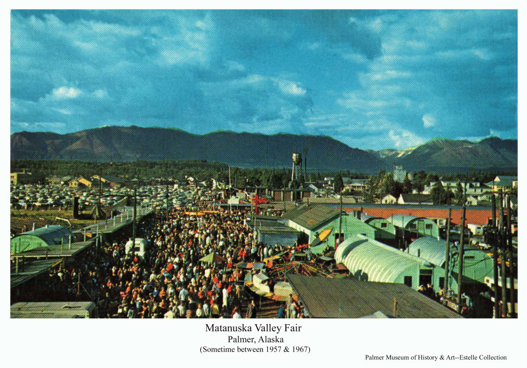
Fair 21
Unknown
A large colorful crowd fills the midway of the Matanuska Valley Fair in Palmer.
This color post card photo shows the Matanuska Valley Fair midway and associated buildings as seen looking north from the rooftop of a building near the south end of the midway. A large colorful crowd occupies the midway in foreground and near middle ground with exhibit buildings, including light green painted Quonset huts, at right. A couple of colorful mechanical rides are also apparent at right foreground. At left the midway is lined with a row of low booths housing games of chance. Another light green Quonset hut is partially visible at far left in foreground. This building is also partially visible in photo "Fair@34x-Est", indicating they were taken at nearly the same time, and viewed together offer an expanded view. In middle ground beyond the fairground, many cars are visible parked at left with the train depot beyond. The Palmer water tower is clearly visible as is the Co-op grain elevator. Talkeetna Mountains are dark in background with blue and white clouds overhead.
Palmer, Alaska
Fair 22
Unknown
People gather at the Matanuska Valley Fair race track in apparent anticipation of a race to come.
This color postcard photo provides an elevated view over the Matanuska Valley Fairground racetracks showing portions of the horse racing track in immediate foreground and a smaller track inside. Numerous people occupy bleachers in foreground. Beyond the track in middle ground numerous cars of fair attendees are parked. In middle ground beyond the cars numerous city business district buildings are apparent. A narrow band of green timberland appears behind the buildings with purple Talkeetna Mountains in the far background. Printed in red letters near the top of the image over white clouds in the blue sky is "Greetings From The Matanuska Valley". At extreme right foreground a light green Quonset hut is partially visible. The same building appears in photo "Fair@33x-Est", indicating the two images seen together may give an expanded view.
Palmer, Alaska
Farm 11
Ruth DeArmond
Hot beds on Walt Pippel farm
Image is a black & white view of Loren T. Oldroyd, Agricultural Extension Director with the University of Alaska, inspecting hot frames on Colonist Walt Pippel’s farm. The hot frames, filled with soil and planted early in the spring, were covered with window glass panels to capture and retain solar radiation to warm the soil and get a head start on the growing season.
Near Palmer, Alaska
Farm 20
Berts
A.A. Shonbeck's farmstead buildings near Palmer in 1935.
Image shows several log buildings and two larger framed barns in middle ground with a fenced field in foreground beside a gravel road partially visible at near left. Heavy forest forms the backdrop behind the buildings and mountains are faintly visible in far background. White lettering across the lower portion of the photo indicate this was the farm of A.A. Shonbeck near Palmer taken in 1935.
Palmer, Alaska
Farm 27
Dick Estelle
Young Jim Estelle attends the family dairy herd as they feed on their meal of silage after the evening milking.
This photo is dominated by a Colony barn in near middle ground showing the west end and north side, the view taken from slightly below looking up at the barn. The upper hay mow door is open as is the smaller hay mow access door directly below. A mostly enclosed "loafing shed" addition is partially visible against the north (left) side of the barn. Visible directly adjacent to the barn at right stands the skeleton of the wood-constructed upright silo in the process of being torn down as it had been replaced by a pit silo nearby. Close examination shows the roof of the cupola atop the barn is missing, blown off by the winter Matanuska wind. Prominent in front of the barn is a line of Holstine dairy cows feeding on silage distributed on the ground along the wire fence. At far-left young Jim Estelle stands leaning against a fence post.
Palmer, Alaska
Farm 4
Associated Press photo
Ewes and new-born lambs on the Clark farm.
Image shows a springtime scene of ewes and new-born lambs inside a pole fence on Frank Clark's Matanuska Valley farm. A log chicken house is in middle ground with heavy forest beyond. Clark summered his flock on the slopes of Lazy Mountain east of Palmer.
Matanuska Valley, Alaska
Farm Art 1
Rusty Dow
Matanuska Colony farmsteads inspired art such as this sketch used on commercial picture postcards.
This sketch by well-known Matanuska Valley artist Rusty Dow, closely resembles the Colony farmstead established on tract #169 north of Palmer. The image depicts a fall view of harvested hay stacked on vertical stakes to dry in foreground and at right. The typical Colony barn and house dominate the left middle ground with a grove of trees left standing behind the buildings as a windbreak. Lightly sketched mountains in the background closely suggest the actual mountains at the east end of the Valley. This image was printed on picture postcards for sale during the 1950's. (Consult the "Colony Barns" photos in the "Galleries" section of this site to identify which view might have inspired this artistic rendition.)
Tract #169 north of Palmer, Alaska
Farming 17
Associated Press
A crew of workers operates a potato digger on a Colony farm.
Image shows a crew of farmers, soldiers and women operating a potato digger machine on a Colony farm. Farmstead buildings are in background, including a barn, house and outbuildings. Heavy forest is in background.
Matanuska Valley, Alaska
Farming 36
Alaska Visitors Association Photo
Three men inspect a row of recently dug potatoes grown in the Palmer area of Alaska.
This photo shows three men kneeling on the ground, (and a dog, possibly not kneeling) in near foreground studying a row of freshly dug potatoes. The men are identified as Ed Baldwin at left, owner of Baldwin Seed Company; Glen Woods, local Palmer potato farmer in center (whose potato crop is presumably under inspection); and Ed's son Dick Baldwin at right. (Dog's name unknown). Between Ed and Glen the row of dug potatoes can be seen receding to a row of trees at the far end of the field in the background. All three men appear to be smiling as they inspect the heavy crop of large tubers. (The dog appears to be bored with it all.)
Palmer, Alaska
Farming 7
Associated Press
Colony farmer spring planting grain with machinery
Image shows a prepared field with a cat tractor pulling a grain drill and cultipacker in middle ground. One man drives the tractor while another rides the grain drill. A dust cloud rises from the machinery. Heavy forest is at the edge of the field in background. Information with the photo identifies this as Matanuska Colonist Gilford Lemon planting oats and peas for cattle feed on his farm on tract #128, June 6, 1936.
Tract #128 Matanuska Valley, Alaska
Farming 8
Worald Wild Press
Spring plowing with a two-horse team
Image shows two men (one perhaps a soldier) in foreground plowing a field with a single bottom hand plow pulled behind a team of two horses. Several cows are evident on unplowed fields in middle ground. A stump row of trees cleared from the fields is apparent in far middle ground. Heavy forest borders the fields in background with snow-clad mountains beyond.
Matanuska Valley, Alaska
Homestead & Haystacks
Hewitts Photo Shop
A homestead farm with fields of harvested hay put up in stacks to dry
This is a postcard photo of a homestead including fields in foreground with harvested hay put up in stacks. A barn and other buildings are in middle ground with scattered trees. Other fields are in far middle ground with hay stacks and heavy forest beyond. Close examination reveals two different types of haystacks in the far field and a man working there. Mount Susitna is faintly visible beyond the forest in background.
Matanuska Valley, Alaska
Hotel 1
Trachers (Frachers ?) Photos
The Hyland Hotel in Palmer stands as it appeared circa the 1940's.
Image is of the south and east sides of Hyland's Hotel in Palmer. Painted white with dark trim, it stands next to another building behind to the west. A free-standing sign in front identifies it as "Hyland's Hotel". A 1940 era four-door car is parked near the front door.
Palmer, Alaska
Hotel 2
Richard Estelle
This 2025 photo shows recent exterior upgrades to this historic hotel in comparison to the photo "Hotel 1" in this collection.
This 2025 photo of the historic Hyland Hotel in Palmer shows recent exterior modifications in conformance with the structure's listing on the National Regester of Historic Places, while accommodating extensive modern upgrades to the interior. Construction began in 1935, opening for business in 1936, making it the longest serving private hotel in the community. Photo "Hotel 1" in this collection shows the structure as it appeared in the 1940's.
Palmer, Alaska
Inspiration Point 3
Ordway
View of the Chugach Mountains and Matanuska & Knik valleys from Bailey Hill
Image is a southeasterly view from Bailey Hill, north of Palmer, toward the Knik River valley. Chugach Mountains are in background. Middle ground is heavy forest. Barely visible through the trees is a road section before it curves in alignment necessary to ascend Bailey Hill, ultimately arriving at the point from which this photo was taken. This was the only point on the road providing this expansive view of the Valley, thus the local name “Inspiration Point”, and a popular stop for photographs. The road, which ultimately became Glenn Highway, was later straightened to cut through Bailey Hill, eliminating public access to this favorite viewpoint.
Palmer, Alaska
Lodge 4-Sheep Mountain
C.P. Johnson
This photo documents the buildings of the long-standing Sheep Mountain Lodge as it appears to have existed in the 1950's.
This winter image is an oblique view of two log, two story buildings in foreground connected by a single story, flat-roofed entry. Five automobiles of late 1950's vintage are parked at left in front of the lodge. Scattered spruce trees are visible immediately behind and at left of the buildings. In middle ground behind the lodge, occupying the rest of the scene, are rugged and highly dissected mountain peaks and valleys associated with Sheep Mountain of the Talkeetna Mountain Range. Snow covers all with about a foot or so apparent at the lodge level.
On the Glenn Highway north of Palmer, Alaska
Market 1
Richard Estelle
A local area farm family is seen with produce for sale at Palmer's weekend Farmers' Market.
Image shows a portion of an open sided shed with an overhead sign identifying it as Palmer's "FARMERS' MARKET" located near the northwest corner of the Quad at the intersection of Evergreen Ave. and Valley Way. Three booths are visible. At the center booth stands Ruth Estelle and her daughter Beth with bags of potatoes on display for sale and other items laid out on a bench. An unidentified woman is partly visible in the booth at right. At left stands an unidentified woman holding a bag of Estelle's potatoes and a young woman stands next to her. At far left stands Tom Moyer, the manager of the market.
Palmer, Alaska
Matanuska Townsite 1
Matanuska townsite buildings
Image is a northeast view of Matanuska townsite. Railroad tracks are in immediate foreground, numerous tents and buildings are in middle ground with trees and mountains beyond. Numerous signs are visible on buildings and several people are evident.
Matanuska, Alaska
Matanuska Valley Air View 1
Johnston
Aerial oblique view across the farm land south of Palmer, across the Matanuska River & up the Knik River valley
Image is a low oblique aerial view across farm land of the “Springer System” south of Palmer in the foreground, across the Matanuska River in middle ground, and up the Knik River valley to the Knik Glacier. The Bodenburg Butte is visible at right. Farms and forest clearing patterns, stump rows and roads are apparent.
Matanuska Valley, Alaska
Matanuska Valley Air View 2
Johnston
Aerial oblique view across farm land southwest of Palmer, including Matanuska and the Matanuska Experiment Farm, across the Matanuska River to the mountains beyond
Image is an easterly low oblique aerial view across farm land southwest of Palmer, including Matanuska and the Matanuska Experiment Farm, across the Matanuska River to the mountains beyond. Bodenburg Butte is visible. Farms and forest clearing patterns, stump rows and roads are apparent.
Matanuska Valley, Alaska
Matanuska Valley Air View 3
Robinson
Aerial oblique view across farm land south of Palmer, including the City of Palmer, the Matanuska River and the Talkeetna Mountains in background.
Image is a northerly low oblique aerial view across farm land south of Palmer, including the City of Palmer and the Matanuska River to the Talkeetna Mountains beyond. Farms and forest clearing patterns, crop patterns and roads are apparent.
Matanuska Valley, Alaska
Mine 16, Independence
Vern Brickley
The large Independence Gold Mine in the Talkeetna Mountains above the Matanuska Valley is near the end of its operational life after producing over 165,000 oz of gold.
This westerly summer view shows most of the lower buildings and development associated with the Independence Gold Mine on the valley floor with rugged mountains in near background. Various milling facilities and tailing deposits are apparent on the slope above the collection of administrative buildings and bunkhouses. A building is visible perched on the mountainside at left center at the mouth of an "adit", or horizontal tunnel to extract the gold ore. Access to the site was by tram not apparent in the photo. Waste rock from the mining is visible as a cone-shaped pile dumped at the base of the mountain. A similar operation is apparent on the mountain at right center with a larger extent of waste rock below the adit. This site was accessed by means of stairs and enclosed walkways visible leading up to a white building near the adit. Snow is gone from the valley but lingers at the higher elevations just above the mine workings. Low alpine vegetation is apparent on the valley floor in foreground but no trees exist as the whole scene is above timberline.
Talkeetna Mountains north of Palmer, Alaska
Nurse 3
Ruth DeArmond
Red Cross Nurse, Miss Pearl Williams, maker her rounds in a horse cart.
Image shows a woman, identified as Miss Pearl Williams, Red Cross Nurse, in a cart pulled by a white horse, on a gravel road. Two automobiles are on the road behind the cart. Trees and clearing slash are visible in background.
Matanuska Valley, Alaska
Nurse 4
Ruth DeArmond
Rec Cross Nurse, Miss Pearl Williams, making her rounds throughout the Matanuska Valley by horse cart.
Image shows a woman, identified as Miss Pearl Williams, Red Cross Nurse, in a cart pulled by a white horse. A log House, identified as the home of colonists Joe and Blanch Puhl, is in the background. A tent is also visible.
Matanuska Valley, Alaska
Palmer Air View 14
Unknown
Aerial view of Palmer in the 1940’s
Image is a high oblique summer view of Palmer, Alaska looking northeast across the town to the Matanuska River and the base of Lazy Mountain. Local homesteads and other clearings within heavy forest are apparent as are roads, streets and community buildings.
Palmer, Alaska
Palmer Air View 16
Hewitt's Photo Shop
Aerial view of Palmer, August 1935
Image is a black & white high oblique view including much of John Bugge’s homestead, the “Tent City” of Palmer, patches of cleared land and uncut forest. The “Wasilla road” is apparent to Bugge’s hill.
Palmer, Alaska
Palmer Air View 26
Jim Balog
This aerial view shows the physical relationship of the city of Palmer to the surrounding agriculture and forest land and to the Matanuska River.
This color aerial oblique north-oriented view shows the extensive agriculture land use pattern south of the city of Palmer. A large section of the center of this area would later become the Alaska State Fairgrounds, first occupied by the Fair in 1967. The Rebarchek colony farm (identified by the red-roofed barn near the center of the image) was added to the Fair property in 2002. The city of Palmer is visible at the upper left and portions of the Matanuska River are visible at the extreme upper left and upper right.
Matanuska Valley, Alaska
Palmer Air View 4
Associated Press
Aerial view of Palmer's "Tent City"
Image is a southerly oblique aerial view showing a cluster of tents at the Palmer townsite adjacent to the railroad line with patches of forest and fields in the foreground. Dense forest and the Matanuska River are in middle ground and snow-clad mountains are beyond.
Palmer, Alaska
Palmer Air View 6
Jack B. Anderson
Color aerial oblique view across Palmer and Matanuska River to Knik Glacier and mountains.
Image is an oblique southeasterly summer view across Palmer and the Matanuska River to Knik Glacier and snow-clad mountains beyond.
Palmer, Alaska
Palmer House
WP (ACME) press photo, photographer unknown
"Palmer House" rooming house
Image shows a white, two-story house in middle ground with a white picket gate and gate post arch holding a sign "Palmer House Rooms" in foreground. The "S"s on the sign are printed backwards. A man is walking on the path towards the house. Owned by Jim Felton, this was the most available lodging in the local area prior to the coming of the Matanuska Colony. Rooms reputedly contained two or more beds to accommodate all travelers, typical of Alaska roadhouses in the day.
Palmer, Alaska
Palmer Street 45
Richard Estelle
Estelle’s Flowers & Gifts and other businesses on S. Alaska Street
Image is a street view of businesses on the west side of South Alaska Way located between West Evergreen and West Dahlia Avenues. Signs identify businesses shown as The Warf Restaurant, City Craft Station, The Valley Sun, Valley Frontiersman, and Estelle’s Flowers and Gifts. Part of the building occupied at the time by Allen & Peterson is visible at right.
Palmer, Alaska
Palmer Street 46
Richard Estelle
Buildings and businesses at S. Alaska St. & W. Evergreen Ave. in Palmer
Image is a street view of businesses on the west side of South Alaska Way located between West Evergreen and West Dahlia Avenues and a partial view of a building on the south side of West Evergreen Ave. A sign identifies a business shown as The Gold Nugget… south of West Evergreen. Fronting on South Alaska Street are the Chase Lounge, The Warf Restaurant, City Craft Station, The Valley Sun, and Valley Frontiersman.
Palmer, Alaska
Palmer Street 47
Richard Estelle
Buildings and businesses on S. Alaska St. in Palmer
Image is a street view of businesses on the west side of South Alaska Way located between West Evergreen and West Dahlia Avenues and on the north side of West Dahlia Avenue. Signs identify businesses as Estelle’s Flowers & Gifts, Allen & Peterson, First Interstate Bank, and Koslosky’s Department Store containing an Insurance office and a Liquor Store. A portion of the Valley Hotel is also visible.
Palmer, Alaska
